
Anyone who has lived through increasingly torrid city summers knows that there are days when setting foot outside is anything but a recommendable experience. The motionless air, the sizzling tarmac, the burning skin, the sensation that even breathing is too much effort. In Milan, in 2025, we experienced this kind of day often: according to data collected by Fondazione OMD, there were fifty-eight days with a maximum temperature above 30°C, of which as many as sixteen had temperatures above 35°C; seventy-three "tropical nights", meaning those in which the minimum temperature never dropped below 20°C, twenty-seven in June alone – the second hottest June in the last 129 years.
Temperatures in the city can be as much as four to five degrees higher than those in the surrounding countryside, a phenomenon known as the "urban heat island", which is, fortunately, being discussed more and more. The causes are multiple, ranging from the substantial emissions linked to human activities, such as exhaust fumes or air conditioning systems, to the obstacles that buildings pose to the free circulation of wind. One of the main factors is, in any case, the high level of soil sealing: a grassy surface absorbs and releases much less heat than tarmac; at the same time, thanks to a phenomenon called "evapotranspiration", the water found in the surface layer of the soil passes into the air, thereby lowering the temperature; not to mention the beneficial effect provided by shading.
This is why we prefer to stop in a tree-lined avenue, storm the city parks, and choose to lengthen our route by a good block to avoid an unplanted street. There's no need to know the meaning of "heat island" or the historical temperature series; it's intuitive: in green spaces, in summer, one feels better because the thermal stress to which our organism is subjected lessens. Certainly: but how much does it lessen?
This is one of the questions that the CRANES Lab (Urban Research Laboratory for Architectural and Energy Systems) at the Politecnico di Milano is trying to answer. To explore the subject, I met with Francesco Causone, Associate Professor in the Energy Department at the Politecnico and scientific lead for the department within the La Goccia project, and Alessia Banfi, energy engineer and post-doctoral researcher and project manager of the La Goccia project.
For several years now, the CRANES Lab has been studying urban overheating and measuring the positive effects of urban greenery on individual wellbeing. What does your work consist of and where did it start?
Francesco Causone. It's now a well-known issue that one of the possible solutions to the problem of urban overheating is to increase the amount of greenery – and when I say greenery I mean vegetation, plants, parks. Public bodies are investing heavily to increase urban greenery. However, when you increase the number of trees, you also increase the costs related to their maintenance, which fall on the citizenry. This is an important issue: it's not enough to create new greenery, you also need to maintain it well. Greenery in the city, limited by tarmac and buildings, doesn't have the same compactness and resilience as a wood or forest, and is therefore more fragile when faced with extreme weather events, as happened in Milan in 2023, when many trees fell following a severe storm. Any municipal administration must therefore carefully evaluate the cost-benefit ratio related to urban greenery, and to do this there's a need for comparable and measurable data. This is where we come in.

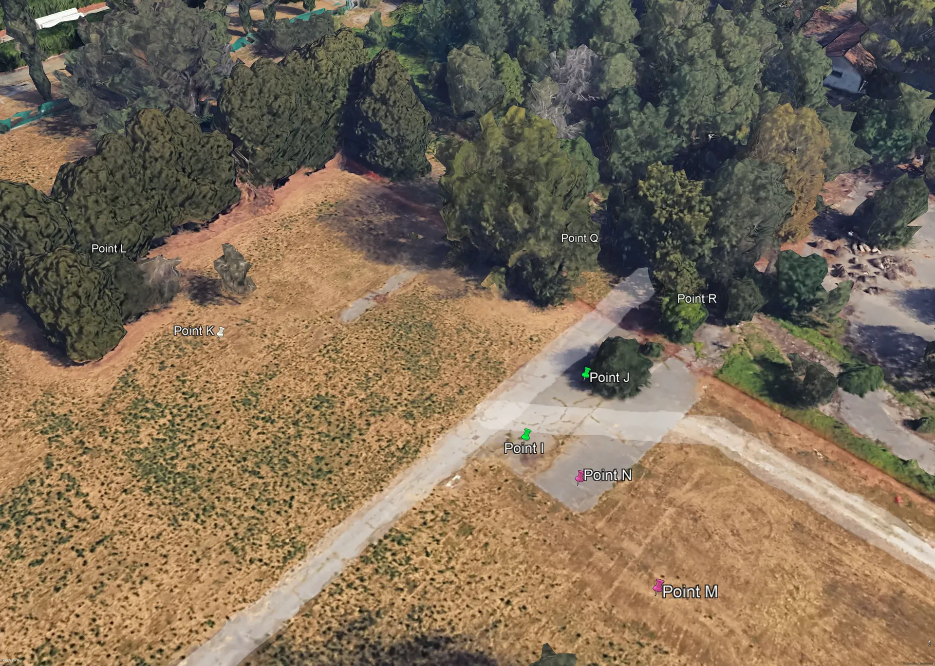
I mesurement points all'interno della Goccia. Immagini campagna Polimi.
In what way?
F.C. We collect microclimatic data – air temperature, mean radiant temperature, wind speed, relative humidity, solar radiation – in different locations, for example on a sunny tarmac area, a shaded tarmac area, a green lawn, a dry lawn; then we process them with the objective of providing a numerical quantification according to an outdoor thermal comfort index called UTCI (Universal Thermal Climate Index). Our measurements are "point measurements", meaning relative to individual points, because it's impossible to map an entire surface; therefore, once we've obtained the data, we use it to "validate a numerical model", as we say in technical jargon: a 3D modelling activity that allows us to recreate the microclimate of an area on the computer, and then simulate different possible climatic conditions. Once the model is complete, we'll be able to visualise not only today's city, but also tomorrow's. The objective is to provide urban planners with scientifically accurate data and models that will be useful both for developing urban planning projects and for communicating them to the citizenry.
Before delving into your work, and within La Goccia, I have a question. Earlier you mentioned "microclimate" on more than one occasion. What does that mean?
F.C. It's actually a term that can give rise to a bit of confusion. At a geographical level, when talking about climate, depending on the scale used, different denominations are used. There's "macroclimate", which is the climate that characterises a fairly large region, such as England; there's "mesoclimate", which refers to a more circumscribed area, for example the Black Forest. But even in an area of these dimensions, significant climatic variables can exist, and this is why the concept of "microclimate" was introduced, which is the most interesting as far as human life is concerned. Microclimate is determined by the nature of the soil, topographic elements, vegetation, and the presence and type of buildings, all variables that lead to even significant differentiations in temperature, atmospheric humidity, and wind distribution. A typical microclimate is the urban one. However, when very detailed measurements are taken, as we do, we prefer to speak not so much of microclimate, but of "thermohygrometric comfort", because the microclimatic parameters are processed into thermal comfort indices: the UTCI index I mentioned earlier.

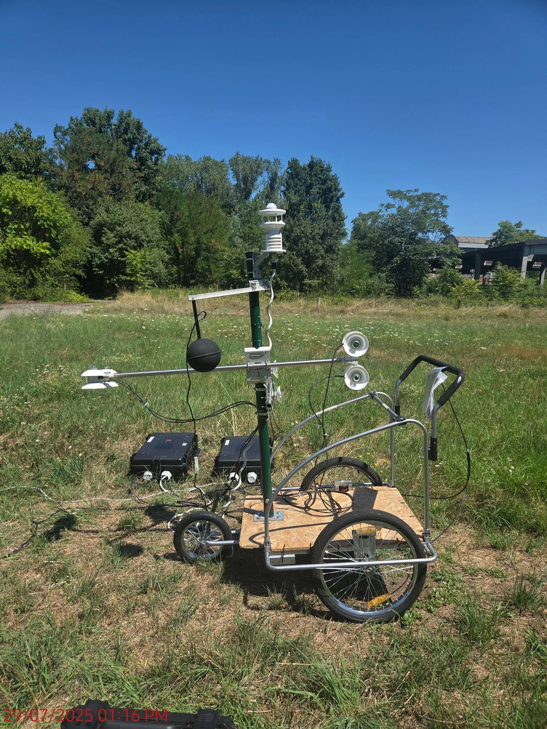
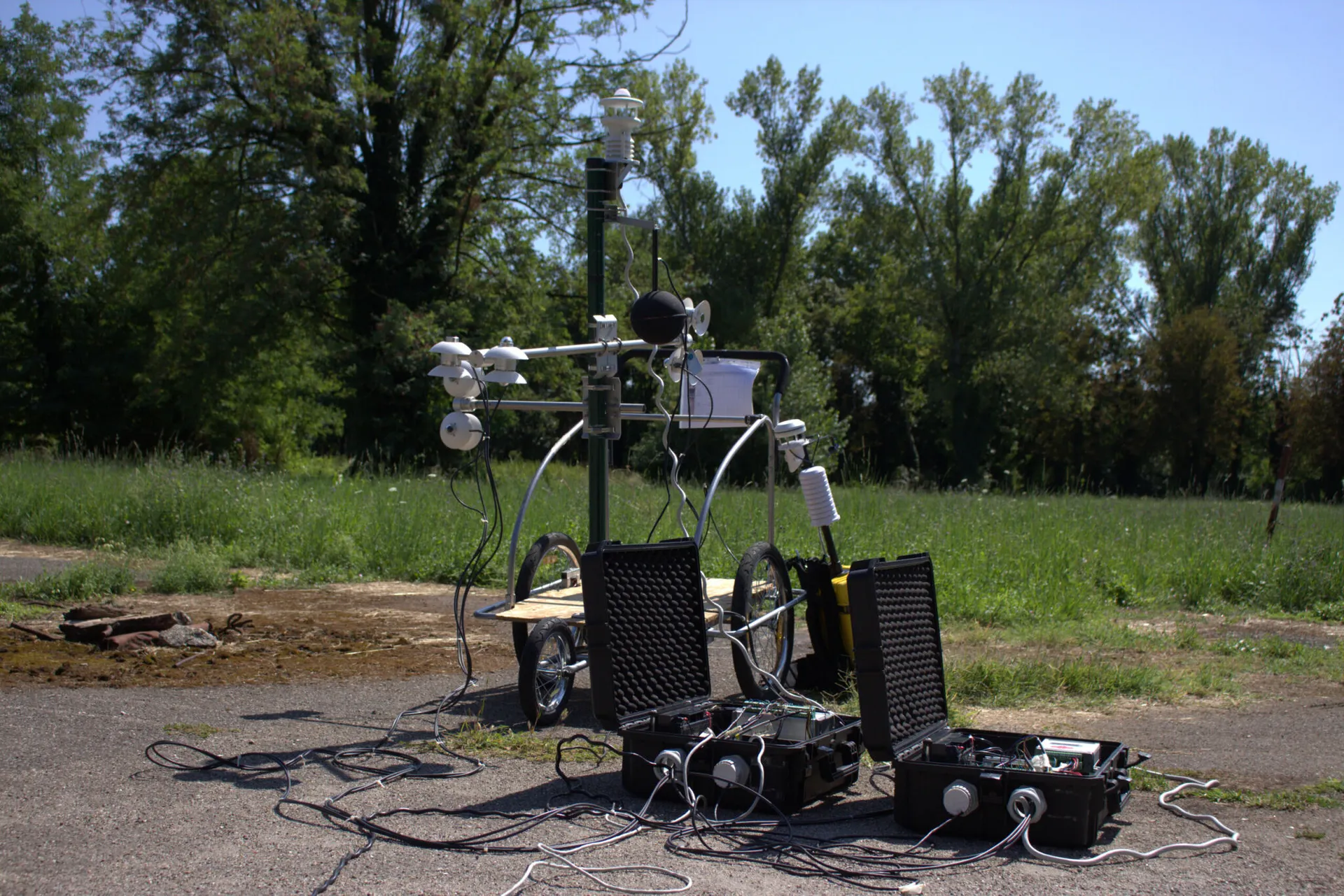
La strumentazione usata alla Goccia per la raccolta dei dati microclimatici. Immagini campagna Polimi
If I've understood correctly, within La Goccia you're carrying out this type of measurement.
Alessia Banfi. Exactly. Our activities linked to the project began last year with the microclimatic measurement campaign, which lasted twenty-five days, between 21 May and 31 July. We went into the field during the summer, because it's the most interesting time for this type of analysis, and we managed to capture the heat waves at the end of June as well. We used innovative instrumentation, which we developed in our department over the years, and which consists of two stations interconnected to the same data logger. We positioned them at two points characterised by different and comparable conditions: for example, two points both in the sun, but one on tarmac and the other on a green lawn; or two points both in the shade, one on tarmac, one on the green lawn; or, two points both on tarmac, shade and sun... Then we rotated the pairs of points.
The fact of using two stations simultaneously was our intuition and allows us to have immediately comparable data: the two devices are calibrated so as to guarantee that the measurements are carried out in the same way, avoiding errors linked to different instrumentation or sensors with different precision and accuracy. The stations mount a multi-parameter sensor, which allows us to acquire data on air temperature, relative humidity, wind speed and direction, global radiation, and a "globe thermometer", which is a copper sphere painted black, with a temperature sensor inside: it allows us to detect a temperature which, then processed through formulas and combined with other data, allows us to derive a very important variable, the "mean radiant temperature", which expresses the thermal exchanges between the human body and the surrounding surfaces.
F.C. It's fundamental for our work because the thermal comfort that human beings perceive depends on two main drivers: air temperature and the temperature of surrounding surfaces. This is why, if we enter a cavern, we feel less hot than outside. In the outdoor environment, mean radiant temperature is an important variable because the sun, when it strikes the skin directly, immediately increases the sensation of heat, even if this doesn't correspond to an increase in air temperature.
Whilst Francesco Causone and Alessia Banfi tell me about their measurements, I glance at the photographs included in the dossier they've shared with me, pausing on the two monitoring stations: mounted on a mobile support, with dozens of sensors resembling coils paired with long aluminium poles jutting out in every direction, they have a simultaneously retro and futuristic appearance. They remind me of the imagery from the series Tales from the Loop, based on the works of Swedish artist Simon Stålenhag.
F.C. In parallel, our colleague Daniele Santucci from Climateflux carried out "climate walks" in the wood. With a rucksack fitted with instrumentation similar to ours – slightly less scientifically accurate because it has to be carried on the shoulders – Santucci walked the entire La Goccia area. What we're doing now is relating our point measurements with his spatial measurements.
In addition to the data collected last year, we have other data, because we've been carrying out this type of research for some time, and already in 2024 we had access to La Goccia. We've activated several degree theses on the subject: one of the first was precisely that of Alessia Banfi in 2020-2021; then, in 2023, the doctorate of Natalia Alexandra Bernal Quintero began, within the scope of the national doctorate in Sustainable Development and Climate Change (SDC). Quintero is currently carrying forward the work of the CRANES Lab together with us. Last year, we then had a degree thesis for the Building Engineering course, which analysed the 2024 data collected at La Goccia, and very soon another student will graduate who, together with Banfi and Quintero, carried out the field measurement and data analysis activities in 2025. It's an aspect I care a great deal about, the fact that our research also includes students.
Have you already managed to obtain some indications from the data collected?
A.B. The main aspect of our work is managing to quantify. Some results at first glance may seem trivial, such as the fact that the presence or absence of shade leads to differences in the comfort index. What we do with our work, however, is give a quantification to this effect. Under the shade of vegetation, conditions of null or moderate thermal stress are reached – so an individual can feel comfortable – whereas in areas in the sun, thermal stress can be very high; data that was also recorded during a full heat wave. This type of result allows us to go to the authorities and affirm that urban greenery has an evident benefit for the thermal wellbeing of the population.
F.C. Another interesting result is the fact that the thermal stress conditions perceived on tarmac and on unmaintained greenery, therefore on dry grass, are the same. Again, this means that it's not enough to promote greenery in the city, you also need to promote its care, because dry grass has the same thermal effect as tarmac.
The analyses are at the moment very scientific, traditional, but we'd like to take them in future also onto the practical level of data usability, to create services for the citizenry or operators. The same type of instrumentation we're using was, for example, recently used to evaluate the comfort conditions of tennis players during the Australian Open: under certain conditions, the match was interrupted; under certain others, the roof over the stadium was closed. In our case, one could relate our data with that calculated by the city's monitoring stations and refine the models that evaluate the conditions in which it's better for people not to expose themselves to the outdoor environment due to the heat effect; thus arriving at a differentiation by area. Many discussions could be opened. Even property value by urban area could be further qualified based on the presence of greenery, and its maintenance. These could be useful indications for imagining enhancement interventions in specific neighbourhoods, guided by public bodies.
Is it in this context that the second part of the research, that of urban modelling, fits in?
A.B. Up to now we've talked about the measurement campaign, but it's only the first phase. Our work then develops into a modelling and simulation activity, for which we collaborate with Professor Riccardo Mereu and Engineer Ruggiero Signoriello, both from the Energy Department at the Politecnico. We're replicating the La Goccia area and the surrounding area on the computer with 3D software, and in this model we'll simulate urban fluid dynamics and temperature trends. In this way, we'll map conditions on a large scale and see them graphically in an immediate manner. From the La Goccia area, a similar model could then be developed for the entire city, and create it on different future scenarios: imagine Milan in twenty years under the influence of climate change, and imagine it with new parks and new greenery, or with a different type of vegetation...

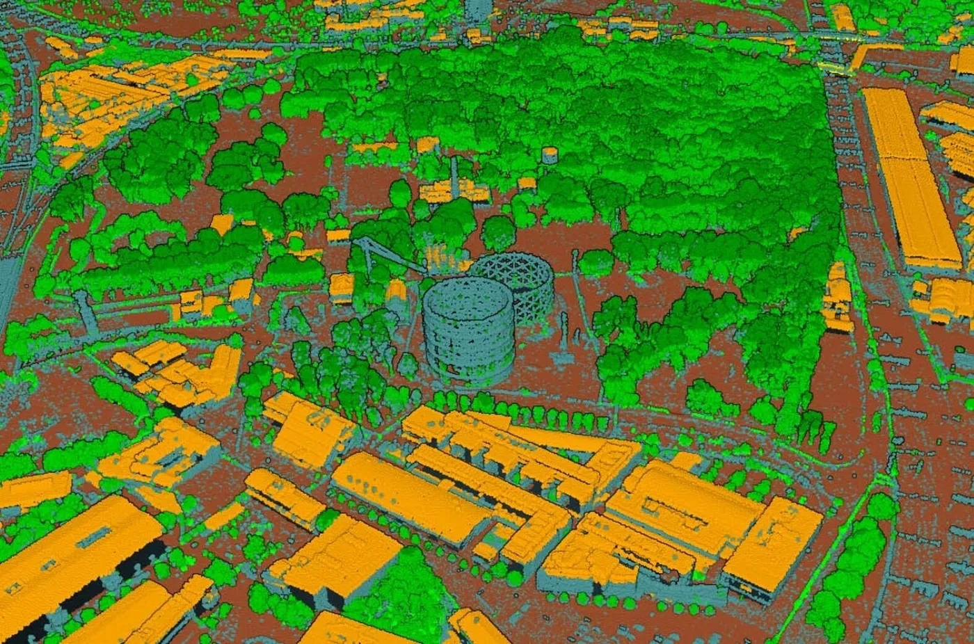
Una veduta della Goccia fotografata con la termocamera. Immagini campagna Polimi.
Broadening the field a bit beyond your research as well, in your experience what are the advantages of a wood like that of La Goccia for the citizenry from the point of view of thermal comfort?
F.C. It's not a single park that can change the microclimate of the city and not even, in my opinion, that of a neighbourhood, because the beneficial effect of a park occurs in the area of the park itself and in the immediately surrounding area. The fundamental thing is the overall morphology of urban greenery, the systemic aspect. In our field, we prefer to speak of "green infrastructure", because like the electrical grid or district heating network, greenery can be understood as a true infrastructure which, amongst various beneficial effects, also provides a service of moderating the thermal stress perceived by people. Some reasoning we're doing with colleagues from other universities indicates to us to "insinuate" greenery into the urban territory, therefore to arrange connections between the different parks to allow the thermal effect to penetrate the built environment. There are two points to keep in consideration. One: greenery must be proportionate in terms of mass with respect to the built environment. Two: it's important that parks are interconnected with each other. Moreover, this connection also benefits other ecosystem services, for example the famous green corridors that allow animals to move.
This, however, is my personal vision, and the models we're developing will also serve us for this: once we've managed to simulate the actual state of the territory, we'll be able to simulate a series of future scenarios. As we were saying, based on La Goccia, we'd like to arrive at modelling the entire city of Milan, so as to provide precise numerical results – which is our idée fixe. Can one have, thanks to greenery, in a given area, a reduction in extreme stress during a heat wave? If so, for how long? And how far does it extend?
Michele Turazzi. Michele Turazzi lives in Milan and works in publishing. He has published the novel Prima della rivolta (Nottetempo 2023, winner of the Demetra Prize for Environmental Literature 2024) and the narrative reportage Milano di carta (Il Palindromo 2018).